

Discovering Cities: Lidar Past, Present & Future
In the final installment of our 3-part series on lidar we are rounding up the discussion by looking at the role of lidar in our cities. In these instances, lidar is instrumental in digging up the past, working in the present and planning for our future.
Mayan Ruins
Our first city belonged to the Mayans, in what’s called a ‘cradle of civilization,’ one of six areas in the world where ancient civilization arose independently. Once a thriving hub of culture, commerce and magnificent architecture in modern-day Guatemala, the city was recently discovered under a thick canopy of rainforest vegetation with the help of an airborne laser terrain mapping sensor. The Teledyne Optech Titan sensor was used by the University of Houston’s National Center for Airborne Laser Mapping (NCALM) to identify hundreds of previously unknown structures, including raised highways and complex irrigation and terracing systems.
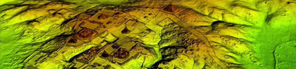
After the collapse of the Mayan civilization, their cities and monuments were quickly covered by thick rainforest, hiding the ancient civilization from airborne observation and making it very difficult to survey on foot. Flying high above the rainforest, Titan’s lasers penetrated the canopy to collect almost a million data points per second from the forest floor, giving archaeologists a “bare earth” view of the structures underneath. Having rapidly covered 2,100 km2, Titan revealed massive amounts of ruins hidden below the forest, showing that their urban centers were significantly larger than archaeologists had previously thought.
Of particular interest to the archeologists was the maze of roadways linking the different cities in the area. The wide roads indicate traffic was heavy even 1000 years ago, and the raised highways suggest that planners wanted to prevent waterlogging of the roadways during the rains.
San Diego MTS
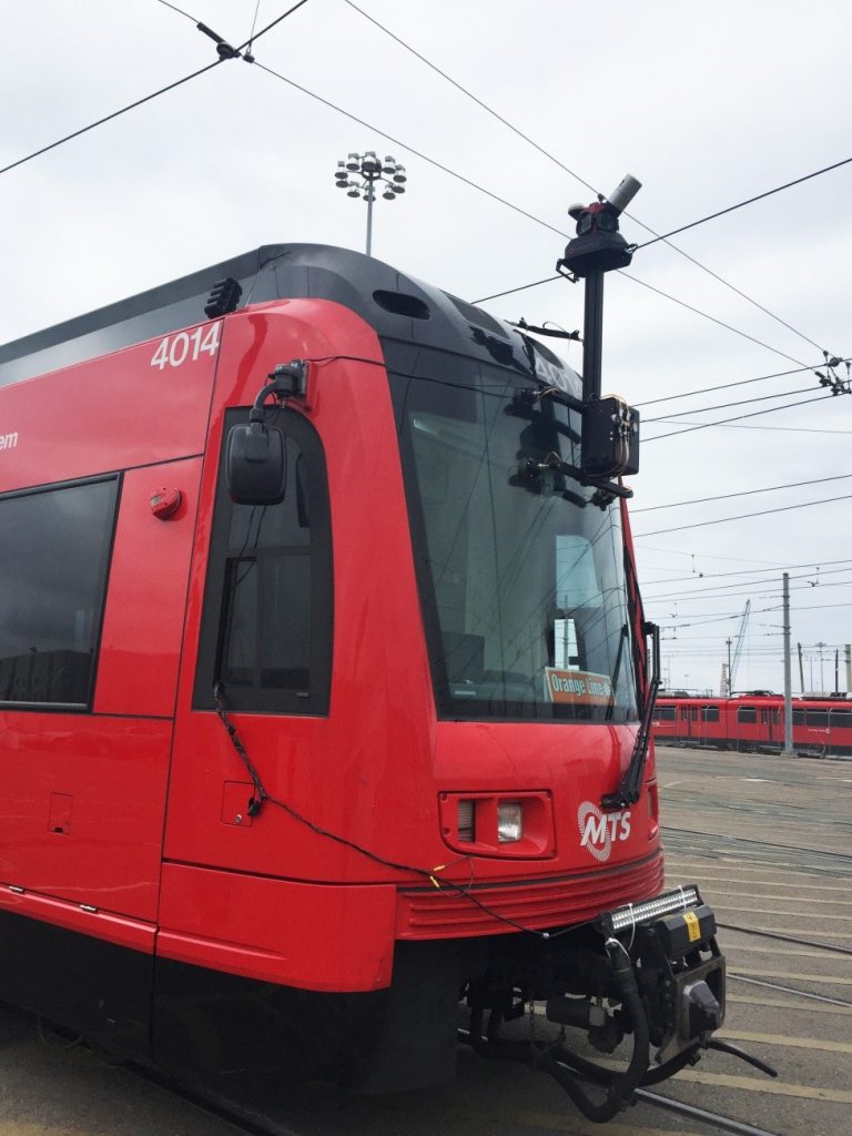
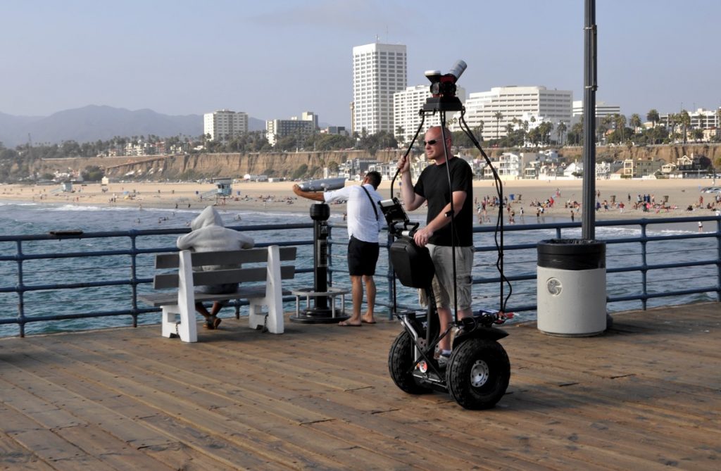
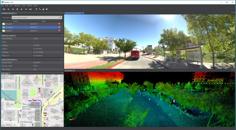
The San Diego Metropolitan Transit System (MTS) has 106 miles of track and 100 bus routes to serve approximately three million people in San Diego County. Managing, maintaining and servicing this vast network could quite easily prove to be a challenge. Many state Departments of Transporation (DOTs) use mobile lidar data collection services to keep track of their mass transit systems, and the San Diego MTS recently used an Optech Maverick Mobile Mapper to map its train routes. The Maverick is light enough to be worn on a backpack, carried by a Segway or strapped to a car’s roof, so it was simple to design a new prototype suction cup mount to attach it to the windshield of a commuter train.
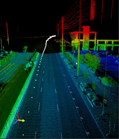
Data collected by the Maverick and processed by the Roadview (Workstation) software gave MTS an accurate GIS inventory of all trackside assets, which will allow them to inspect and monitor track conditions from the safety of the office. This also gave the MTS imagery that can visually teach their trainees about defensive driving, what to look for in tough intersections, speed limits through certain areas, and much more, all in a classroom setting.
After seeing the value in mobile lidar and 360° imagery, MTS also collected a few pilot routes for its Bus Division. The entire collection process took less than a day. For bus applications, transit agencies can use the resulting dataset to perform an inventory of bus stops and other assets along the routes. The imagery also will be used to train new bus drivers and bus drivers switching from one route to another, allowing them to drive through their assigned route virtually and see obstacles, tight corners, and other potential difficulties.
Smart Cities
According the the United Nations, the world’s urban population has been growing rapidly. In 1950, there were 746 million living in urban areas. By 2014, that number had quintupled to 3.9 billion. Current predictions estimate that “the urban population will double… and the total urban area will triple…” That means that by 2045, the world’s urban population is expected to surpass 6 billion. Dealing with such massive growth is a daunting logistical challenge, and many are turning to technology to help deal with it. The concept of “smart cities” is therefore foremost on the minds of city planners and urban developers.
A smart city uses information and communication technologies to improve the quality of life of its residents. It enhances the delivery of services and provides comfortable mobility by making more efficient use of physical infrastructure, conserving energy, monitoring the environment and providing a greener footprint among other things. Lidar, whether airborne, mobile or static, has proved to be a very useful technology for the planning of smart cities.
Here are some of the conventional applications where lidar assets help a city to function well:
- Airborne lidar can efficiently map extensive urban areas by providing accurate terrain models that are invaluable for city and infrastructure planning
- Mobile lidar facilitates the collection of spatially correct data from street level on a large scale. Rather than survey individual buildings or areas, mobile mapping systems can be deployed to map entire cities or hundreds (even thousands) of kilometers of transportation corridors.
- Static lidar can be used for as-built surveys, continual structural monitoring, or inspection of existing structures.
There are myriad possibilities for using lidar data to find new applications that will help the “smart cities” live up to their name.
 How LIDAR is helping to clean up our oceans
  Getting the Big Picture