

Keeping an eye on our galaxy: an overview of satellites
While Galileo was first able to prove that moons orbited planets and planets orbited the sun in 1609, and Kepler to model how those orbits worked, it took much longer for us to understand why they did. One of the first proofs was provided by Isaac Newton 70 years later. It was Newton who first proved that the reason planets remain in their orbits is related to why objects fall to Earth when we drop them: gravity. Earth’s force of gravity pulls all objects down if they are not held up by some other force. Newton is also arguably the first person to come up with the idea of a satellite: He had the idea that if you fired a cannonball from a tall mountain at a high enough velocity, counteracting gravity just enough, it would keep falling toward and around earth without ever hitting it: essentially achieving orbit. His work propelled our understanding of space and objects in it, coming around eventually to the launch the first artificial satellite into orbit.
However, it wasn’t until the mid-20th century that the idea of launching a satellite became a reality. The first, the Sputnik, was launched into space on October 4 1957 by the Soviet Union. Ever since, many other countries have joined the race to space by launching artificial satellites into orbit. But what exactly are satellites and what role do they play in our lives?
A satellite is an object in space that orbits or circles around a bigger object. There are two types of satellites, natural—like the moon orbiting around earth—or artificial—like a space station orbiting around earth. There are dozens of natural satellites in our solar system, with every planet having at least one moon. For example, as of 2017, Jupiter is known to have 69 moons, Saturn has 53 moons, Uranus has 27, and Neptune has 13 moons.
Classifications of Satellites
Artificial satellites take many different forms depending on the functions they play in space, and are classified based on their proximity to Earth’s surface. The three common classifications are: Low-Earth Orbit (LEO), Medium-Earth Orbit (MEO), and Geosynchronous and Geostationary Orbit (GEO).
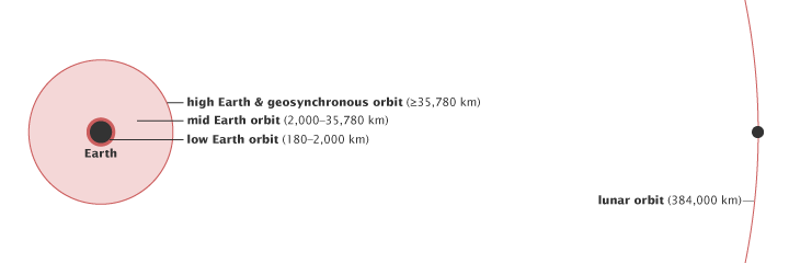
Low-Earth Orbit (LEO)
LEOs are the most common forms of satellites. It is estimated that about 800 satellites are currently orbiting in the low-earth region, including the International Space Station. LEOs are satellites that orbit close to Earth, usually at a height of about 111 miles (180km) to 1,243 miles (2,000km). These types of satellites move at incredibly high speeds of approximately 27,400 km/h, allowing them to complete a single orbit in approximately 90 minutes. LEOs usually work in groups, called satellite constellations, because of how quickly they change their positions relative to the ground. Due to the fact they constantly move in and out of earth-bound transmitting stations, they have to work in large numbers to maintain uninterrupted signal. Additionally, LEOs are much cheaper and faster to launch as compared to other artificial satellites, and have a very low transmission delay— .05 seconds – for a round trip to be complete. These features make them ideal for communication and imaging functions. LEOs are typically used for data communication like emailing, and video conferencing, as well as earth monitoring, to see the surface of the earth more clearly.
Medium-Earth Orbit (MEO)
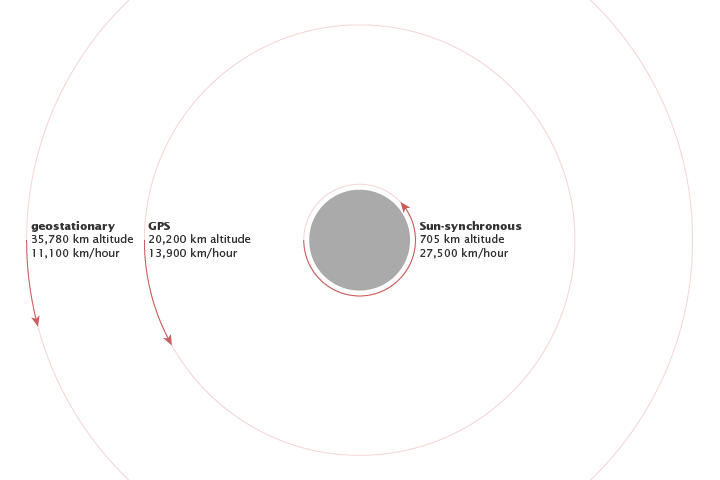
MEOs are satellites that usually orbit at a height of between 1,243 miles to 22,223 miles. These satellites also move at relatively fast speeds and are able to complete an orbit around earth within 2 to 24 hours. A major advantage of MEOs over LEOs is that they are able to cover a greater area of the earth with fewer satellites, thus reducing the need to have multiple satellites working at once. Their distance relative to Earth also means that signals only have to travel a short distance to the receiving end, thus permitting the use of more modest-sized antennas. This helps minimize/eliminate transmission delays, as less time is spent for the signal to travel to the satellite and back down to the receiving station. For example, a MEO satellite requires only about .1 seconds for a round trip to be complete, making it especially suited for real-time communication. Due to their effectiveness at this altitude, MEOs are mainly used for providing connectivity and in geographical positioning systems (GPS).
Geosynchronous and Geostationary Orbit (GEO)
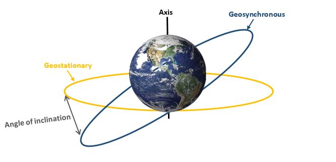
GEO satellites orbit at a height of approximately 22,223 miles above Earth’s equator. These satellites typically orbit at the same speed as the Earth turns, and so take 24 hours for a single orbit to be complete. GEOs take longer to complete a single orbit compared to other types of satellites because Earth’s gravity pulls strongly against satellites that are closer to its center than further way. A key point to note is that every geostationary orbit is geosynchronous, but not every geosynchronous orbit is geostationary. This is because a geosynchronous satellite does not always have to remain exactly above the Earth’s equator, but a geostationary satellite must always be above the Earth’s equator. To put this another way, geostationary satellites always fly over Earth’s equator to remain at a fixed spot, but geosynchronous satellites may have an elliptical orbit—drift east and west over a fixed point—or may orbit in a path that is not aligned with Earth’s equator, usually north or south of earth’s equator during one full orbit.
Due to the large surface area GEOs are able to cover, they are mainly used for weather forecasting, satellite TV and radio, as well as global communication. Geostationary satellites are particularly valuable for weather and terrestrial monitoring because of their ability to provide a constant view of the same geographical area.
One of the disadvantages of GEOs is that there is usually a considerable communication lag between the satellite and the station on earth due to the large distance between the satellite and Earth’s surface. This therefore increases the amount of power needed to transmit signals, and consequently makes GEOs expensive.
The Anatomy of a Satellite
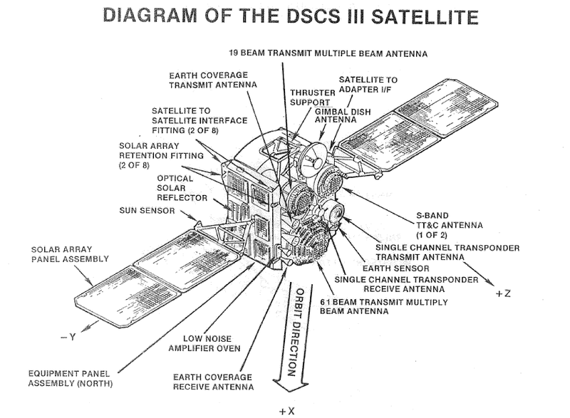
The structures and designs of a satellites currently orbiting in space have greatly advanced from some of the first satellites that were sent into orbit. With satellites continuously exposed to very harsh weather conditions in space, they have to be built with the most advanced materials that are capable of withstanding the extreme atmospheric conditions in space. Additionally, the materials selected have to be lightweight, as this has a direct impact on the cost of a space flight.
Some examples of commonly used materials include Kevlar, titanium and aluminum alloys. Kevlar is a very lightweight yet durable material that is able to withstand the harsh temperatures in space. Titanium and aluminum alloys are also commonly used because of their durability and lightweight.
Majority of the satellites sent into orbit consist of three key systems. These include the antenna system, a station keeping system and a transponder.
Antenna system
The antenna system on an artificial satellites serve two main purposes. Firstly, it receives and transmits telecommunication signals between the satellite and the station on earth. Secondly, the antenna system provides tracking, telemetry and command (TT&C) functions which allow the satellite to remain connected to the facilities on the ground. The TT&C function is particularly important because it monitors the health and status of the satellite through analyzing the data transmitted from the satellite. It also tracks the location of the satellite at all times, and therefore a failure of this system may mean that all control over the spacecraft may be permanently lost, with no means of regaining control over it.
Station keeping
A station keeping system is needed to help keep a satellite in its orbit. In space, various disturbing forces can alter a satellite’s orbit over time if left unchecked, thus affecting its performance. For instance, the gravitational force exerted by the sun and moon can affect a satellite’s orbit. To control these forces, or prevent them from affecting a satellite’s performance, there is a need for a station keeping system to correct these effects. This is usually achieved by employing certain maneuvers that are exerted periodically to keep the satellite in orbit. Alternatively, hydrazine gas can be ejected from thruster nozzles on the satellite’s housing to correct these effect.
Transponder
A transponder is a communication device that is attached to a satellite to receive and transmit radio signals at a specific frequency range. When the transponder system receives a signal, it amplifies it and then transmits the signals at a prescribed frequency range back down to earth. The main purpose of the transponder is to transfer all signals the satellite receives.
Obtaining Satellite Imagery
To help us monitor and learn more about our planet, satellites are usually equipped with sensors capable of detecting radiation from different parts of the electromagnetic spectrum, depending on the satellite’s function.
For satellites that are used for mapping and monitoring applications, they are typically equipped with sensors capable of detecting only visible light. Much like conventional cameras, these sensors are able to detect electromagnetic radiation with a wavelength of between 380nm and 760nm.
Satellites equipped with sensors to detect near-infrared radiation are generally used to detect plant material. These sensors detect electromagnetic radiation with a wavelength of between 750nm and 2,500nm.
For satellites used for weather forecasting and climate monitoring, sensors capable of detecting thermal energy are usually used. These sensors are able to pick up radiation with a wavelength of between 700nm and 1mm. For example, onboard the recently launched Aeolus satellite for wind monitoring is a powerful laser instrument known as ALADIN. ALADIN works by emitting ultraviolet laser beams into the atmosphere and measuring the reflected return signal from the particles in the atmosphere. To measure the distance of the returned ultraviolet laser pulse, ALADIN is equipped with CCD sensors from Teledyne e2v. The Aeolus satellite is the first climate monitoring satellite with equipment capable of globally monitoring earth’s winds.
Satellites used for detecting the size of forests, mapping geographical features, detecting rainfall and analyzing ocean waves are usually equipped with sensors that detect radiation from the microwave end of the spectrum. These sensors pick up short wavelengths from about 10cm to 1mm.
Looking further ahead
Satellites have played an enormous role in improving our understanding of our own planet and the world above us. From providing us with detailed information about our climate, to enabling explorations of other planets in our galaxy, there is no doubt that satellites continue to have an impact on our lives. As technology continues to advance, the role satellites play will continue to expand to provide us with a deeper understanding of the world around us and of the galaxies above.
