

Farming for the Future
In the first part of this series, we covered the history of precision farming. In its early days, precision farming was characterized by a technology transfer initiative that saw the introduction of technologies like GPS and GIS into the farming industry. Initially driven by the need to increase farming efficiency and productivity, this goal has remained very relevant, especially as the changing climate continues to affect crop yields and as the human population continues to grow. Like before, precision farming involves the use of science, high-tech sensors, and analysis tools to improve farming efficiency. Not only are farmers able to increase their output, they are also able to minimize costs of production.
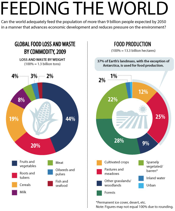
In 2017, it was estimated that the world’s population was 7.6 billion. This number is projected to reach 8.6 billion in 2030 and 9.8 billion by 2050. People are also changing. Studies have shown that people on average have become taller, heavier and older. Thus, requiring 6.1% more energy compared to 50 years ago.
Additionally, there has been a growing concern for preserving our environment. It is estimated that food loss and waste cost about $940 billion and have a carbon footprint of 4.4 Gt of CO2 annually — which is more than 8% of global greenhouse-gas emissions. Governments, businesses, and individuals are becoming more environmentally conscious; they want to know how food is produced, and the impact production methods have on the environment.
Given the rapidly increasing population size and diminishing quantity of arable land, there has been an increasing reliance on new technology to increase yield and efficiency. Such precision farming tools can increase output, while minimizing certain factors such as the amount of pesticides, fertilizers, land-use, and other costs that naturally come with increasing production – helping farmers move towards a sustainable future.
Advanced Precision Agriculture: From Passive to Active
Previously, GPS and GIS technology allowed for passive monitoring by collecting geospatial data. Farmers used this geospatial information primarily for farm planning, yield mapping, soil sampling, and crop scouting. Geographical data restricted farmers to information on the condition of the entire crop, rather than the individual plants. This made it difficult to make decisions about where to apply water, pesticides, or fertilizers right down to a one square meter scale.
Advances in technology – particularly in the development of digital imaging – have enabled farmers to actively manage their assets at a more precise level. They are no longer restricted to the passive monitoring of their farm through geographical data. The cameras and sensors that are available today, combined with automated vehicles, can deliver real-time data on the physio-chemical conditions of plants and livestock. This information gives farmers an insight to plant and animal health, as well as soil conditions right down to the individual plant or animal – this allows for isolated applications of pesticide, water, or fertilizer. These devices can also be interconnected into one network commonly referred to as the Internet of Things, or in some cases the “Internet of Plants”. The development of IoT allows farmers to control their farms through the mobile devices in the palms of their hands.
Remote Sensing
Remote sensing plays a crucial role in precision farming. It can be dated back to the 1990’s, during the introduction of satellite spectral imaging. Satellites are equipped with sensors that are capable of sensing in the spectral regions which humans cannot observe, such as infrared, microwave, and ultraviolet. However, the challenge was that satellite data is low resolution, and perhaps more importantly, the refresh rates are slow. By the time a satellite sweep is done it may be too late. This is where imaging based at ground level (either drones or on farm equipment) becomes a game changer.
Today, Teledyne DALSA’s ultra-high resolution panchromatic imaging and Teledyne Optech’s lidar and multispectral sensors can be mounted on to drones and other airborne vehicles. Closer to ground level, the sensors are capable of revealing ripeness, water and nutrient levels, and helping farmers detect hard-to-spot diseases in both plants and animals. Thermal imaging systems can also help detect early signs of disease or pest infestations, particularly with livestock by checking for signs of inflammation or fever.
Drones and Automation
Drones, unmanned automated vehicles (UAV’s), and other robots are changing the way we see traditional farming. They complete the physically daunting tasks that naturally come with producing food for entire populations. Even the tractor, a classical image of farming, is being engineered to be autonomous.
UAV’s are connected to sensors and can be programmed to pick fruit when they’re ripe, target and eliminate weeds, sow fields, monitor livestock, and complete other tasks that may require intensive repetition and precision. Drones equipped with thermal imaging cameras can also provide farmers with insight on areas that have water pooling or insufficient soil moisture, helping to improve irrigation.
UAV’s can be equipped with IoT-enabled devices that can feed information to mobile applications which deliver reports and notifications to farmers.
Benefits of Precision Agriculture
The data collected by precision farming technology will help farmers make smarter decisions, and help identify any patterns that will increase or derease output.
The information gathered by such tools can help reduce water and fertilizer use by 20%-40% with no negative impact on yields, and even increase yields in some cases. Additionally, a diseased plant can be difficult to detect in the midst of large crops. However, hyperspectral sensors exhibit a high degree of discrimination, which allows farmers to classify disease conditions and accurately pin-point where and how invasive the disease may be. Hyperspectral and multispectral imaging systems are also cost-effective, and are able to give consistent results.
The ability to detect diseases and deficiencies with precise detail over a large area, can save farmers hours of physically scouting their fields. Cameras and sensors give farmers insight on areas that need attention, giving them the necessary information to allocate resources efficiently, resulting in better plant and animal health as well as reduced waste.
Challenges
Despite the benefits that precision agriculture brings, it faces a large hurdle in wide-spread adaptation. Rural areas are lacking in access to good connection to networks. It is clear that the implementation of IoT in agriculture can boost the efficiency in crop management; however, this system requires connection to internet and electricity. 89% of the world’s population and 78% of harvested croplands live in developing countries. Unfortunately, for many developing countries, infrastructure and access to electricity is still a challenge. Precision agriculture is primarily benefiting those who have access to internet networks and to those that can afford it. However, there are initiatives that implement affordable IoT-enabled irrigation devices, and offer free digital agriculture platforms in Asia and Africa Government leaders need to play their part in providing farmers with the necessary infrastructure that will give them access to electricity and networks. Countries need to work towards creating a foundation in which technology can flourish and benefit the entire population in all areas of the world, so that all of humanity can reap its benefits.
