

How Lidar and Sonar Can Help Manage Icebergs
A tool called the Smart Ice Management Systems (SIMS) uses lidar and sonar to profile icebergs for oil and gas companies working on the open ocean.
Ever since a certain traumatic event concerning a famous ship and a large block of floating ice in the North Atlantic in 1912, humanity has had a special neurosis about collisions with icebergs.
If you work in the northern seas, icebergs can be a distinct concern, threatening life and livelihood. They are large, oddly shaped, contain more mass under the water than above, and are often unpredictable. Oil and gas companies that explore and drill in remote locations have to contend with icebergs that could collide with their production platforms, moored drilling units or underwater infrastructure like pipelines and wellheads. It’s wise to never underestimate the type of damage that a massive, moving block of ice can do.
Iceberg towing is the practice of moving an iceberg away from where humans are working by casting a net around it and tugging it to a different location with a ship. Seems like a simple concept, but iceberg management can be quite complicated, made more difficult by the fact that teams often do not know the underwater shape and mass of the iceberg they want to move.
A team of researchers from C-Core, a Canadian environmental engineering company working out of the Grand Banks of Newfoundland, built a decision support tool called the Smart Ice Management System (SIMS) that can be deployed from a boat to map the visible and subsurface shape of an iceberg and help teams decide how to move it.
Sonar and Lidar: Working Together
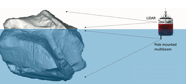
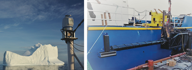
SIMS consists of two primary pieces of hardware: a subsurface multibeam sonar unit attached to a hydraulic pole that can be dropped in the water; and a lidar system on the deck of the boat. By attaching the multibeam sonar system—a R2 Sonic 2026—to a retractable hydraulic pole, researchers can map the underwater portion of an iceberg from a 90° angle, a sideways orientation as opposed to downwards, which would point towards the seafloor. Both the sonar and the lidar system—a Teledyne Optech Polaris LR—are paired to an Applanix POS MV Wavemaster inertial navigation system.
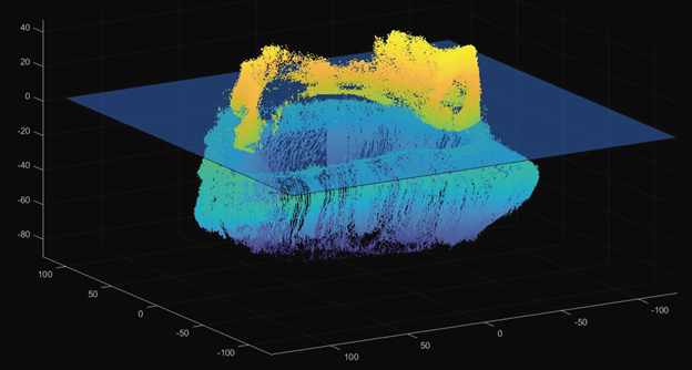
A ship equipped with SIMS profiles an iceberg by circumnavigating around it twice, a process that takes about 15 to 30 minutes, depending on the mobility of the vessel and size of the iceberg. Data is acquired with commercial surveying software paired with a simple user interface, developed specifically for SIMS, so that it can be operated by the ship’s crew as opposed to trained surveyors.
The initial field programs for iceberg profiling with SIMS were conducted in 2018 and 2019 off the coast of Newfoundland and Labrador. About 150 icebergs were measured between the two trips, providing a significant database of high-quality 3D profiles.
Acting on Iceberg Data
Icebergs are not stationary objects. They drift and rotate in the water with six degrees of freedom (three rotational and three translational). An iceberg traveling 0.5 meters per second can move around 600 meters in 20 minutes. Thus, when profiling an iceberg there is often quite a bit of noise in the data that needs to be cleaned up, which C-Core does with its own algorithms.
Iceberg towing can be an inefficient process. According to the Program of Energy Research and Development’s Comprehensive Iceberg Management Database, 38 percent of iceberg towing attempts result in rope slippage events, and 10 percent result in the iceberg rolling. Slippage or rolls can cause significant delays while nets and ropes are retrieved and untangled. Tools like SIMS can be used to help mitigate that kind of effort. For instance, SIMS can help identify the stability of the iceberg in order to assess which direction it can be safely towed. SIMS can also help determine how to fasten the net to an iceberg, avoiding trouble spots that could cause slippage.
SIMS provides a tool to determine how dangerous an iceberg can be to an approaching ship or a stable platform.
“Without any information on the below water geometry, it is difficult to determine the contact location on the structure (e.g., shaft or caisson for a stepped shape gravity-based structure) should an impact occur,” researchers wrote in The Journal of Ocean Technology.
It’s also helpful to have a general idea of where an iceberg is going. SIMS has a forecast tool used to predict where an iceberg will drift in the water. This can often be a difficult task, given that icebergs have complex geometries and the situations on the water can change (such as water current and wind speed) can change frequently. By using the iceberg profile data from SIMS, data points such as shape, mass, volume and draft (the distance between the waterline and the deepest point of the iceberg) can be added to drift forecasts, helping to improve accuracy.
“In the model, the currents and winds are forced against a two-dimensional projection of the iceberg,” the researchers wrote. “Average results for the forecast iceberg position versus observed at 24 hours show approximately a 20 percent decrease in positional error when iceberg profiles are incorporated into the drift model as opposed to using estimated iceberg draft and mass.”
Increased Efficiency and Safety
Understanding how an iceberg will act in the open water or when being towed will make it safer for people to work near them, whether on ships or moored platforms. Data from SIMS also allows for iceberg towing ships to be more efficient, which can help save many hours of frustrating work.
The next steps for SIMS will be to speed up the data processing and cleaning algorithms, to help make faster and more informed decisions when managing icebergs. C-Core is also developing a method to deploy the multibeam sonar tool through a ship’s hull so the hydraulic pole does not affect the operations of the vessel.
 How LIDAR is helping to clean up our oceans
  Charting the Deep: Understanding Our Oceans, Envisioning Our Future