

It’s Earth Day 2019. Climate change is real. Here’s how digital imaging is helping.
An inside look at how imaging is helping in the fight for Earth's future.
Earth day is the world’s largest environmental movement celebrated in more than 192 countries all over the world. It aims to educate and empower people to get involved at a local, state, national and global level. In recent years, there has been a push to try to reverse the effects of climate change before it’s too late. Earth Day is another reminder that we need to act on global warming and provide solutions on how to embrace a clean, sustainable future.
With technology evolving every day, it is becoming easier to monitor climate change on a global scale, using a variety of different devices. Teledyne Imaging has a wide range of leading edge vision solutions that are currently onboard satellites in space, monitoring weather and storms, and in recycling facilities, sorting plastics and polymers for re-use. Sensor and camera technology are instrumental in helping scientists to track and monitor the effects of climate change and global warming.
The majority of environmental experts agree that the leading cause of global climate change is a result of the ‘greenhouse effect’ – a natural process that consists of heat from the sun being trapped in our atmosphere as it radiates from earth towards space. There are many gasses that contribute to the greenhouse effect, including carbon dioxide, naturally released through processes such as respiration but also a direct result of human activities such as deforestation and burning fossil fuels. Another naturally produced component contributing to climate change is methane, a byproduct of the decomposition of garbage in landfills and domestic livestock management. Scientists agree that the root cause of the greenhouse effect is mainly attributed to human activities on Earth.
Climate monitoring using CCD image sensors
Over the past 100 years, the global temperature has increased by 0.74°C. As a result, global sea levels have risen by 17 cm. In response, space agencies have developed technology to continuously monitor and inform on the effects of climate change. Technology such as satellites, sensors, radiometers and altimeters are used to observe atmospheric temperatures, precipitation, cloud structures, pollution, and to study the ozone layer. (NASA)
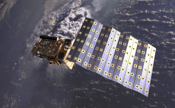
Teledyne e2v is a part of a collaborative program that recently provided custom space grade CCD sensors to the Sentinel-5/UVNS mission. These CCD image sensors will contribute to meteorological observations from polar orbit, increasing the ability for long-term climate monitoring. The mission focuses on monitoring trace gasses in the atmosphere, giving the ESA real-time updates on air-quality and climate monitoring. This mission, lasting 7.5 years, will use ultraviolet, near-infrared, and shortwave infrared imaging sensors to monitor optical depth and trace gasses in the atmosphere, including ozone, carbon monoxide and nitrogen dioxide.
Dust storm monitoring using the TigriSat:
Dust storms are a serious weather condition people experience when residing in countries with extremely dry environments. Countries in the Middle East are among the most effected, largely because of amounts of sand, dust and reoccurring strong winds. The United Nations Environment Program predicted that Iraq alone could experience up to 300 dust storms per year over the next decade. This is expected to increase, as the country’s climate continues to become hotter and drier as a result of global warming. The dust and sand lead to dust clouds, trapping the CO2 and heat in the above atmosphere, as a result, cooling the regions below.

To combat this issue, Teledyne DALSA worked alongside a group of graduate students at the School of Aerospace Engineering at La Sapienza University in Rome, Italy, to develop a satellite to monitor these storms. They developed the TigriSat project, a satellite to orbit the earth, which has multiple subsystems integrated such as image processing capabilities and electronic control interfaces.
The vision system of the TigriSat features a color smart camera with a new scripted algorithm for dust detection. The camera features on-board image processing capabilities and the ability to execute C++ code. One of the largest technological advancements of the TigriSat satellite is the implementation of the controls, which go through magnetic tracks embedded in the solar panels. These embedded magnetic coils provide altitude control to modify the downward-facing viewing geometry of the satellite while in orbit. TigriSat transmits images to two ground stations, one located in Rome, Italy and another in Baghdad, Iraq. The ability to monitor dust aerosols gives better insights into what to expect for upcoming years, including its effects on surrounding areas over time. To learn more about the TigriSat mission visit the mission’s website.
Plastic sorting using machine vision
Although plastic has only been around for 60 years, it has become inseparable from how we live our lives. One of the largest issues with plastic waste is that the majority of it is intended for single-use. Most beverage or food containers aren’t able to be resealed after opening, causing many people to throw them away as it has little use when emptied. As of 2017, only 9% of the world’s plastic was recycled leaving 91% for landfills, or worse, our oceans.
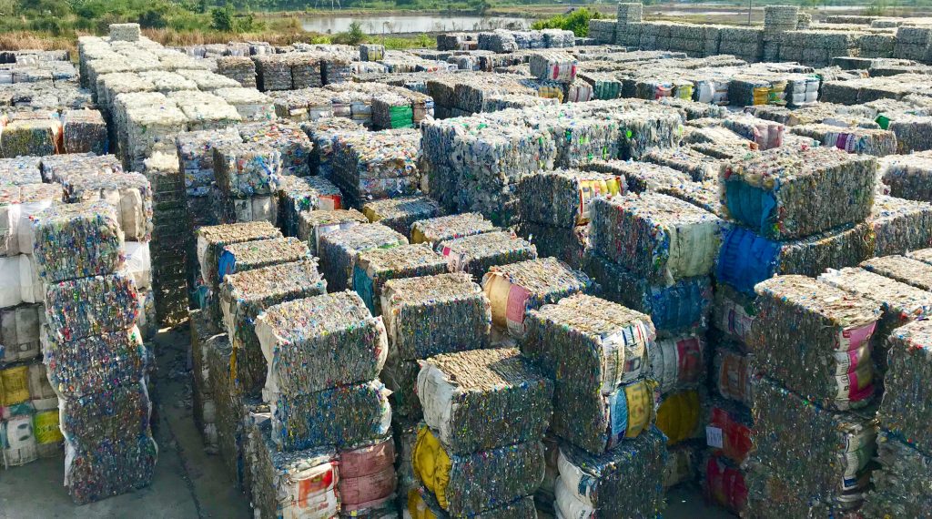
Teledyne DALSA has a variety of vision solutions that are being used to help sort plastic, reducing costs of recycling and improving efficiency, and ultimately, keeping it out of our landfills and oceans. Their line scan cameras are used in visible spectrum sorting, a machine vision solution that is able to distinguish between recyclable and ceramic glass. Another imaging system used in plastic sorting is hyperspectral imaging, which is able to identify the subtle differences between hydrocarbons in paper, cardboard, and plastics.
With nearly 50 different types of plastics, everyone will need to work together toward reducing and eliminating the effects of plastic on the Earth. Plastic sorting enables efficient recycling, resulting in reduced costs and lowering greenhouse gases and toxins in our atmosphere. To learn more about sorting plastic using machine vision, see our other articles on the topic.
Taking steps in the right direction on Earth Day 2019
Originally celebrated on the spring equinox, the United Nations officially designated Earth day as the 22ndday of April back in 1970. Each year, activists around the world partake in activities such as garbage collection, planting saplings, and signing petitions. It is these actions that will help to put a stop to the devastating effects of climate change. For more information on how to get involved in the world’s largest environmental movement visit the Earth Day Network.
 Plastic, Plastic, and More Plastic
  Planet Earth or Planet Plastic?