

Mobile Mapping with Advanced Camera Technology
Horus uses high-resolution FLIR cameras to enable cost-effective automated road inspection at highway speeds
Today, it’s almost second nature to plug an address into a street mapping app to view panoramic photos of what a location looks like before you go there. Whether it’s to explore a vacation spot, view real estate property you might be interested in, or see if a new restaurant has ample parking, it’s a great way to get the lay of the land before going to your destination.
But this technology is even more valuable for industrial applications. Prior to intelligent mobile mapping solutions, public works departments sent employees in vehicles and on foot to visually inspect conditions before dispatching crews for repairs and maintenance on municipal roads, bridges, buildings, and highways.
A safer, effective, and more cost-efficient method is to perform this inspection digitally based on high-resolution image capture. With image-based mobile mapping, local governments can keep their streets and other infrastructure safe while saving time and money.
Video-Based Mobile Mapping
Horus, a systems integrator headquartered in the Netherlands, has disrupted the mobile mapping industry by using imagery data instead of conventional lidar surveying technology for mobile mapping in order to gain more detailed visual images of the assets being inspected. The company sells its mobile mapping systems to service providers who work with cities, towns, and utility companies to help them more effectively inspect, repair, and perform preventative maintenance on infrastructure.
Horus started as a mobile mapping service provider itself more than a decade ago and has since evolved into a software solutions company for the mobile mapping industry. Horus’ mission is to advance technologies and push boundaries to create visionary imaging solutions with the aim to make the world a better and safer place to live and work.
There is a revolution going on within the mobile mapping industry. The originally conservative mobile mapping market is catching up to take maximum advantage of scaling GPU power, advancements in artificial intelligence (AI), and high-end camera systems.
Today, the industry accommodates improved methods of traditional processes, especially now that AI and complex machine learning algorithms are proving to be effective in the field of mobile mapping. Horus’ hardware and software solutions allow them to deliver efficient, automated workflows to get decisive geographic information systems (GIS) data out of street-level imagery. Together with hardware manufacturers, mobile mapping system integrators, and AI, they have developed advanced intelligent video analytics solutions.
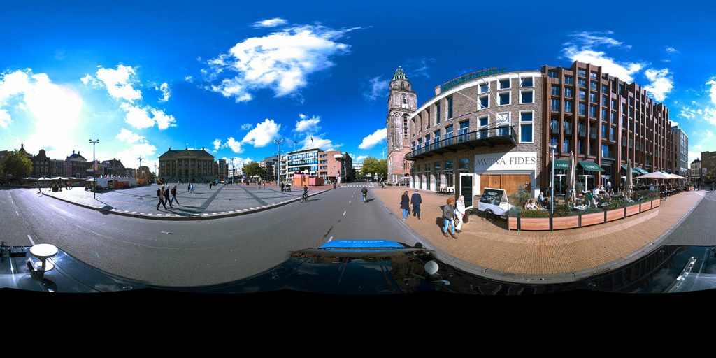
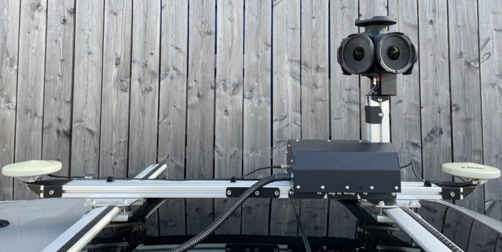
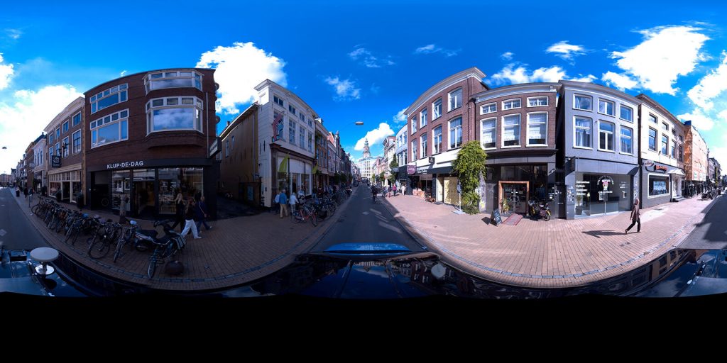
Horus’ CityMapper is a modular mobile mapping system that enables fast and productive capture of road, infrastructure, and city environmental data from a vehicle-mounted device. CityMapper is a turnkey solution that can be mounted on a car, boat, train, or other vehicle. Equipped with the Teledyne FLIR IIS (Integrated Imaging Solutions) Ladybug6 professional 360-degree camera and an Applanix global navigation satellite system/inertial navigation system (GNSS/INS) positional system, CityMapper captures street-level imagery with unprecedented speed, vastly reducing project operating costs and improving safety. The system delivers outstanding geo-referenced immersive panoramic images for road inspections and asset management applications. Automated road inspection can be done 10x faster with AI and the Horus GeoSuite mapping software.
Applications of Video-based Mobile Mapping
Novotecni is a consulting and engineering firm based in Spain. Eduardo Javier Serra explains, “In the past, when we were starting out in the business, we developed our equipment setup in-house utilizing separate GPS, antennas, inertial measurement units, and the Teledyne FLIR IIS Ladybug5. Prior to commencing field operations on a daily basis, a team of two individuals would take anywhere between 45 to 90 minutes to install and initiate the system.”
He continues, “However, at present, with the aid of CityMapper and the Ladybug5+, our team is able to arrive on-site and complete the setup process within 15 to 20 minutes, increasing the amount of time available for capturing images and obtaining results. Consequently, this has led to an increase in the number of kilometers of coverage per day, resulting in fewer days required to finish projects, leading to substantial cost savings, while simultaneously requiring less fuel, thereby reducing our environmental impact.”
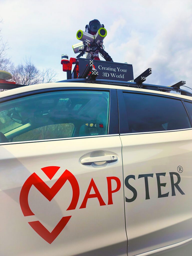
US-based Mastermind, a data collection software and services company, recognized the need to upgrade their existing Mapster system with a higher resolution spherical camera. They chose Horus because their customers expect to be able to zoom in on assets, view them up close, and read detailed information.
They commented, “Our experience with the Teledyne FLIR IIS LadyBug6 camera has been exceptional. Following the cameras’ arrival, and the steady support of Horus during integration, we were up and running in days. The panorama images are beautiful within the Horus GeoSuite mapping software, and the LadyBug6 has proved to be the comprehensive turnkey camera perfectly suited for our mobile mapping services.”
How the System Works
Horus integrated the Teledyne FLIR IIS’ high-resolution 360-degree Ladybug6 camera into its CityMapper mobile mapping solution in a matter of days. Previously, they used the Ladybug5 model camera. They added HORISON real-time anonymization software, which blurs faces and license plates to ensure resulting data is compliant with privacy regulations such as GDPR, LGPD, PDPB and CCPA . Customers can choose to enhance the basic CityMapper including the Ladybug6, with thermal cameras or even higher-resolution cameras when required.
Horus chose to integrate the Teledyne FLIR IIS Ladybug6 into CityMapper because it gives users unmatched precision trigger control and resolution in a field-proven format for applications that require high-accuracy imaging like high-definition mapping, road surveying, and asset inspection. The Ladybug6 is the leading high-resolution camera designed to capture 360-degree spherical images from moving platforms in all weather conditions.
Another reason Horus chose the Ladybug6 camera is that it delivers the industry’s highest accuracy and image quality because of its calibration combined with global shutter CMOS sensors and high-end optics. The camera is able to capture outstanding images across a wide range of lighting conditions with an excellent color response, low noise, and a high dynamic range.
The camera captures, compresses, and transmits 8-bit or 12-bit pixel data with onboard image processing for optimized workflows. The Teledyne FLIR IIS feature-rich Ladybug Software Development Kit (SDK) enables image acquisition, spherical and panoramic image production, and fine-grain control of pre- and post-acquisition camera settings via a user-friendly interface.
Designed for industrial applications in harsh environments, the Ladybug6 is built for the outdoors, with an IP67 rating, industrial-grade connectors, and a wide operating temperature range (-30° C to 50° C).
Novotecni’s Serra comments, “Consequently, this has led to an increase in the number of kilometers of coverage per day, resulting in fewer days required to finish projects, leading to substantial cost savings, while simultaneously requiring less fuel, thereby reducing our environmental impact.”
When mapping roadways for inspection and maintenance, capturing data is just the beginning. The challenge is to securely store, manage and use the data gathered in a timely way. Transforming the data into actionable information is the real end game, and Horus’ GeoSuite mapping software and automated mapping enable customers to make the most of their mobile mapping information.
Imagery-based Mobile Mapping as compared to Lidar
Horus has chosen to base its solutions on imagery, rather than other mobile mapping techniques, such as lidar. Horus’ CityMapper is an imagery-driven mobile mapping solution to capture imagery data at speed and is very cost-effective compared to lidar-only systems.
Lidar technology – an acronym of “light detection and ranging” is a special combination of 3D scanning and laser scanning and is commonly used to make high-resolution maps, but the output is a 3D representation, not actual imagery.
Horus chose to use imagery data because it gives you the needed visual details of the asset’s condition. In certain cases, lidar can be “overkill,” with needlessly higher requirements in terms of pricing, accuracy, and data volume. As the market for imagery-driven mobile mapping solutions is maturing, it is an ideal solution for inspections, inventories, and calculations.
Today’s spherical, thermal, and high-resolution imagery data can now deliver an unparalleled visual level of detail for asset inspection. Mobile mapping systems integrators need to enhance their current product ranges or even the need to build new imagery systems – Horus has done just this with its CityMapper solution, enabling its customers to capture, view, and explore street-level imagery.
Innovation Built on Partnership
Not only does Horus incorporate Teledyne FLIR technology in its own products, Horus has also helped FLIR with its own solutions. Launching its next-generation thermal vision Automotive Development Kit for the development of self-driving cars at the 2019 Consumer Electronics Show, FLIR needed a real-life demo how thermal cameras can improve the safety of advanced driver-assistance systems. Horus helped synchronize multiple the high-resolution FLIR Boson thermal camera with the response times need for an automatic emergency braking system. The Horus Framework made a performant system ready to show in 15 minutes of configuration instead of 3 months of development!
Today Horus software solutions including the Horus Framework are also being used by companies like NVIDIA, Trimble, and Leica, pointing the way towards deeper partnerships and bigger innovations.
 A Smart City to Call Our Own
 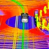 Avoiding bumps on the road: how thermal imaging can improve the safety of autonomous vehicles