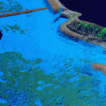
Profiles Mapping the Catalan coast using airborne Lidar bathymetry Charles de Jongh, Sara Pont, Julià Talaya January 22, 2024 Aerial Lidar, Airborne Lidar, airborne survey, CZMIL SuperNova, Lidar imaging, teledyne optech
Science Asteroid Lidar Scans and Soil Sampling: It’s a Dirty Job, But Someone’s Got to Do It Possibility Editorial October 31, 2023 asteroid, Lidar imaging, NASA, Satellite imaging, space imaging, teledyne optech
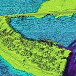
Profiles | Tech Trends Airborne Lidar Bathymetry Data and its Expanding Role in Non-traditional Segments Don Ventura | Possibility Editorial August 30, 2022 Airborne Lidar, airborne survey, Cadastral, lidar, Mariculture, teledyne optech, topo-bathymetry
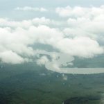
Profiles | Science Dynamic field of view: An answer to cloudy survey conditions Possibility Editorial July 19, 2022 Aerial Lidar, Cameroon, lidar, Lidar imaging, SwathTRAK, teledyne optech
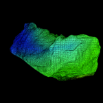
Profiles Emergency Excavation: Underground 3D Scanning in the Himalayas Sajid Mukhtar June 23, 2022 3D modelling, dams, laser imaging, laser scanning, teledyne optech, vision systems
Science | Tech Trends How Precision Forestry Uses Lidar to Manage and Preserve Forests Possibility Editorial September 14, 2021 elevation map, lidar, Optech Galaxy G2, precision forestry, Teledyne e2v, teledyne optech, Terrestrial Lidar
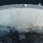
Profiles Lidar makes its points at Europe’s dams Andrew Moller July 5, 2021 dams, environment, IMAGEO, lidar, Polaris, teledyne optech, Terrestrial Lidar
Science | Tech Trends How Researchers Use Lidar To Monitor Rockslides Andrew Moller November 26, 2020 3D imaging, aerial laser scanning, landslides, lidar, Matterhorn, point cloud, rockslides, teledyne optech