

The Highest Fidelity Weather Data In History: The 3rd-Gen Meteosat Is Live
With MTG-I1 open for normal operations, its CMOS sensors will provide the most accurate look into the climate in realtime
For nearly 2,000 years, the science of predicting the weather operated on the same set of principles.
Few of those principles would make sense to a meteorologist of today. Aristotle wrote one of his most influential texts, Meteorologica, in 340 B.C.E. And yet, the philosopher’s thesis was the basis of weather forecasting well into the 17th century.
The problem was that Aristotle wasn’t working with data. Just basic principles. Weather forecasting began to improve when observational data became more widespread.s.. Better instruments and better data gave us marginally better forecasting, but it wasn’t till the 20th century, when we took to the skies, that predicting the weather truly took off. The first weather balloons, carrying sensors (called radiosondes) and cast 30 kilometers into the atmosphere, were launched in the 1920s. This was a great step, but the transformation of weather forecasting truly began when we reached beyond the atmosphere.
TIROS (Television and Infrared Observational Satellites) was launched in 1960 and was the first satellite to give us meteorological data from space. Today, satellites from space agencies around the world give us a continual stream of data, allowing us to encompass the totality of the Earth’s meteorological systems.
The latest and greatest of weather satellites, Meteosat Third Generation (MTG-I1) launched on December 13, 2022 by ESA in partnership with EUMETSAT (European Organisation for the Exploitation of Meteorological Satellites) and is scheduled to begin normal operations at the end of January 2024. The MTG weather system will consist of six total satellites and continue the longest of traditions in human technological innovation, from Aristotle to the Information Age, aimed at answering one of the humanity’s most eternal questions:
“Is it going to rain today?”
Meteosat for the Modern Era
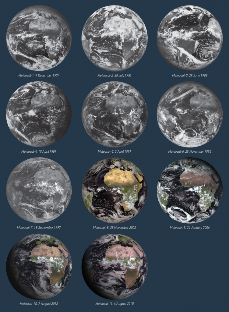
The first generation of Meteosat satellites began launching in 1977 and included seven different models spanning over 20 years. The initial satellites provided images every 30 minutes in three spectral channels including infrared and the visible spectrum along with water vapor. The last of the first generation was launched in 1997 and placed in a graveyard orbit in 2017.
The second generation began launching in 2002, with four different satellites, three of which are still in operation, with the last (Meteosat-11, launched in 2015) planned for decommission in 2033. The primary upgrades to the second generation allowed for scientists to perform “nowcasting” (forecasting for timescales of two to six hours), as well as numerical weather prediction, a concept that began gaining ground in the 1920s and improved through the addition of data and the evolution of computers to crunch ever larger datasets. The second generation of satellites included two sensor packages, the optical imager SEVIRI (Spinning Enhanced Visible and Infrared Imager), and the secondary GERB (Geostationary Earth Radiation Budget) instrument.
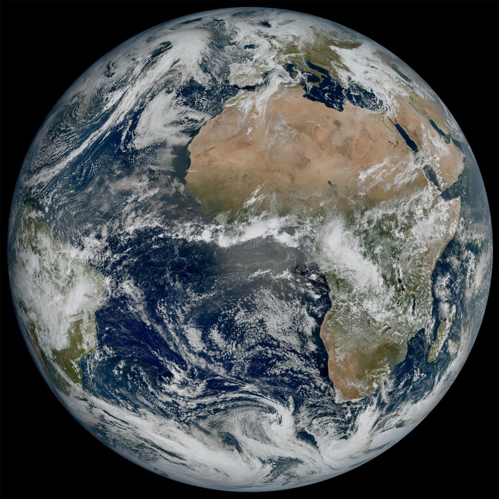
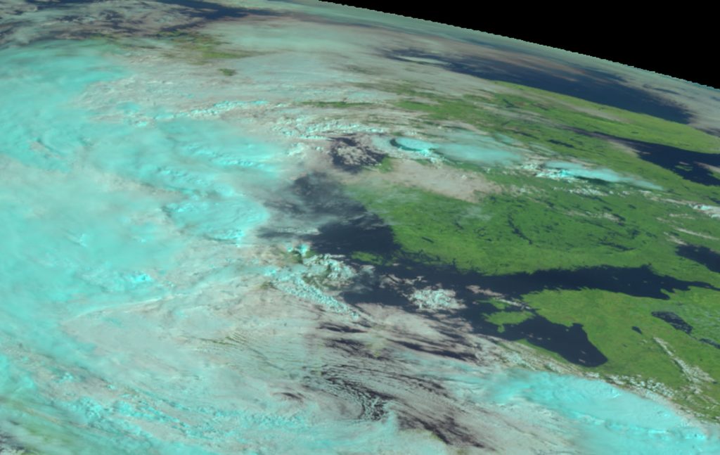
Meteosat Third Generation will consist of four imaging satellites (MTG-I) and two sounder satellites (MTG-S). So far, just MTG-I1 has launched. Its goals are numerous. The satellites will “provide near-real-time snapshots of atmospheric humidity, temperature, and dynamic behavior,” says EUMETSAT. MTG will allow for better nowcasting that will enable authorities to issue alerts in the event of severe weather that can save lives and infrastructure. The higher fidelity of its instruments will provide better data to improve numerical weather prediction. MTG will allow for the continuity of climate records which, when paired with historical data, can help improve modeling.
The MTG-I imaging satellites will carry two sensor packages, the Flexible Combined Imager (FCI) and the Lightning Imager (LI). The FCI is the successor to SEVIRI and will be able to operate on 16 spectral channels, up from 12 on its predecessor, in the visible, near-infrared, and infrared wavelengths between 0.3 and 13.3 microns with a spatial resolution of 1-2 kilometers, with the ability to deliver a full image of Earth every 10 minutes. According to ESA, the FCI will, “offer significant enhancement in detection capabilities (with respect to radiometric, spectral and spatial resolution) resulting in improved forecasts and earlier prediction of severe weather events. The additional channels added to the FCI will ensure improved detection of thin cirrus cloud, aerosols, localized fire events, enhancing products related to air quality and volcanic-ash detection, for example.”
FCI will offer enhancement of the radiometric, spatial resolution, and spectral detection capabilities over SEVIRI. The additional channels will improve detection of aerosols (such as volcanic ash), localized fire events, and thin cirrus clouds. In addition, FCI’s instruments will be able to measure atmospheric winds, humidity and temperature fields, cloud particle properties, cloud types and cloud top temperature, liquid water and precipitation rate, sea ice cover and thickness, snow cover depth, surface temperature of the ocean and land, and vegetation.
The LI provides a new capability to the Meteosat series, providing continuous monitoring of 80% of the Earth’s disc to detect lightning discharges taking place between clouds or from the cloud to the ground. It consists of four optical telescopes that will measure the wavelength of 777.4 nm at a spatial resolution of 4.5 km at nadir, which will be “triggered by optical pulses above a threshold that are initiated by lightning.”
Teledyne e2v is providing the custom designed CMOS sensors for the MTG-I satellites, transitioning from the long-used CCD sensors. Teledyne will provide five (one for each MTG-I satellite plus a spare) CMOS sensors to the mission. The sensor utilizes very large (up to 100µm x 100µm) rhombus shaped pixels which require new and unique solutions to column definition, a pixel readout scheme (utilizing best pixel mapping), and image capture. A special black coating process on the die minimizes reflections within the device.
Climate Data for Everyone
Once the full constellation of MTG-I and MTG-S satellites are deployed and operational, the system is expected to produce, “at least 50 times as much near-real-time data as Meteosat Second Generation satellites.” The data will be disseminated around the world through multicast initiatives with users able to visualize the data through online map services.
The Meteosat satellites will soon be joined in orbit by other climate and weather systems, such as the TRUTHS (Traceable Radiometry Underpinning Terrestrial- and Helio-Studies) satellite, expected to launch in 2026 as a “standards laboratory in space.”
The more data we can collect on the Earth’s environmental systems, the better equipped we will be to understand climate change and how to mitigate the worst consequences of our warming planet.
“Once MTG satellites reach the end of their mission, EUMETSAT will have amassed more than six decades of comparative observations with continuously improving spectral, temporal and spatial resolution,” EUMETSAT states. These datasets are invaluable for providing robust information about changes in the environment on a continental scale that support the development of climate models.”
 The TRUTHS Satellite Will Help Provide the Most Accurate Climate Data in History
  Tracking Climate Change with Satellite-Based Cold Atom Gravity Sensors