

The One-Source Solution
The Advantages of Using a Single Supplier for Survey Needs
Near-shore hydrographic surveying can be a challenging task even in the most ideal conditions. Whether a survey is being conducted to determine the safety of navigation, support construction and infrastructure management, or aid scientific research, survey platforms typically require the integration of multiple sensors operating simultaneously. Advances in sensor technology mean sensors can operate with incredible coverage and precision, resulting in significant volumes of data collected in a single pass to maximize the survey efficiency of the platform.
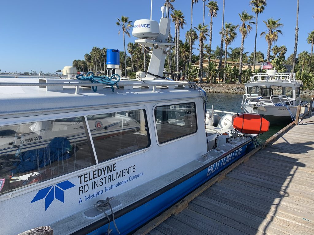
Through the collaboration of several business units under the Teledyne Technologies umbrella, an integrated solution demonstrated how customers can easily collect and process data utilizing world-leading sensors and software with unparalleled efficiency. In a combined survey undertaken on the West Mission Bay Drive Bridge, San Diego, California, a high-density multibeam sonar sensor was paired with a high-density laser scanning system (Lidar) in addition to the supporting inertial positioning system and sound-speed sensors. With this single-source solution, users can achieve high-accuracy data for real-time analysis, providing quick responses with less resource requirements.
A highly efficient data collection effort can introduce a significant bottleneck as the surveyor must then take the collected data and post-process them into whatever data products are required for the project. As a solution, equipment and workflow was optimized within the Teledyne ecosystem to maximize the potential of the data within the most efficient time possible.
Equipment Selection
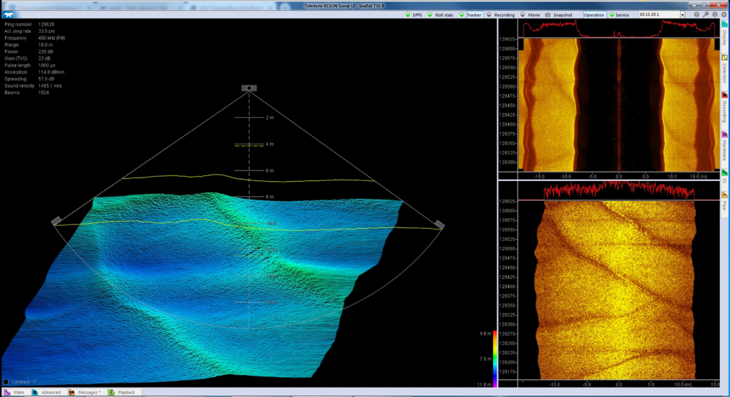
Teledyne RESON SeaBat T50 Sonar. SeaBat T50 produces unprecedented clean data, providing faster operational surveys and reduced processing time. The SeaBat T50 is fully frequency agile from 190 to 420 kHz, allowing for improved swath performance and reduced survey time under challenging acoustic conditions, and offers a beam resolution of 0.5° by 1°, with up to 1,024 uniquely beamformed soundings per ping.
Built to facilitate a wide range of hydrographic tasks, the SeaBat T-series offers several data management tools. Both the user interface and the sonar are fully user configurable—or the user can select the intelligent Tracker Autopilot—and maintain focus on other tasks at the same time. Data acquisition on the West Mission Bay Drive Bridge was acquired in exactly this mode, the sonar adjusting its operating parameters to the optimum settings, based on an ongoing analysis of the data returned in real time.
Teledyne Optech TLS-M3 LiDAR Scanner. The TLS-M3 from Teledyne Optech is a high-resolution laser scanner system (2 mm at 100 m), capable of collecting up to 500,000 points per second with survey-grade accuracy (5 mm). It can reach up to 2,000 m and delivers a highly detailed 3D point cloud of all above-the-water features.
The sensor is fully integrated with PDS software from Teledyne RESON. PDS controls the unit, manages the survey parameters, streams the data, synchronizes and displays the 3D point cloud in real time.
Installation
For the collection of the data at West Mission Bay Drive Bridge, the installation of the SeaBat T50 was a normal bathymetric installation, with the unit mounted straight down. The system can steer the acoustic beams if required, for instance, when looking at bridge support struts or quay walls, but many inspection-specific installations have the option to install the system with a physical tilt to enhance the acoustic return.
Teledyne Optech TLS-M3 laser scanner was installed with the system on the starboard side of the vessel, scanning vertically, as the vessel will provide the horizontal movement. The scanner was mounted on a fixed mobile bracket that holds the instrument on the correct orientation, even on multiple installation projects. This is essential to hold the boresight calibration and speed up the workflow for data collection.
The equipment was co-located as closely as possible with the inertial positioning system to minimize the potential for lever arm error.

Data Acquisition
Teledyne PDS software is designed to efficiently create high-quality, fast results—whether it is for laser and multibeam surveys, single-beam surveys, construction or dredging work.
The acquisition of the Teledyne Optech TLS-M3 laser scanner and the Teledyne RESON SeaBat T50 data was supported via integrated drivers inside Teledyne PDS, enabling the surveyor to control all acquisition components from one piece of software.
Survey progress is shown real time in 2D and 3D views using a color-coded digital terrain model (DTM) and/or historical raw point cloud. Various filter settings can be applied to the multibeam and laser data online, thus providing real-time data processing, which can always be adjusted or tweaked in offline processing later if desired. QC displays reassured the operators that the data were of the desired quality.
The 3D editing module combines 3D swath editing, multibeam and laser calibration routines, DTM modeling and editing, CUBE modeling, WCD data visualization and SVP editor. Combining all these features into one module saves a lot of time for the data processor.
Processing and Analysis
Teledyne CARIS, a provider of marine geospatial software, offers a comprehensive portfolio of products for a full Ping-to-Chart solution. The CARIS Onboard is a product built on decades of hydrographic data processing expertise to provide automated near-real-time processing and product creation to manned and unmanned survey platforms. CARIS Onboard integrates seamlessly with the platform sensors and software to automatically produce real-time products for both the multibeam and laser scanner, including real-time position and motion correction, as well as application of sound velocity data from the Rapidcast.
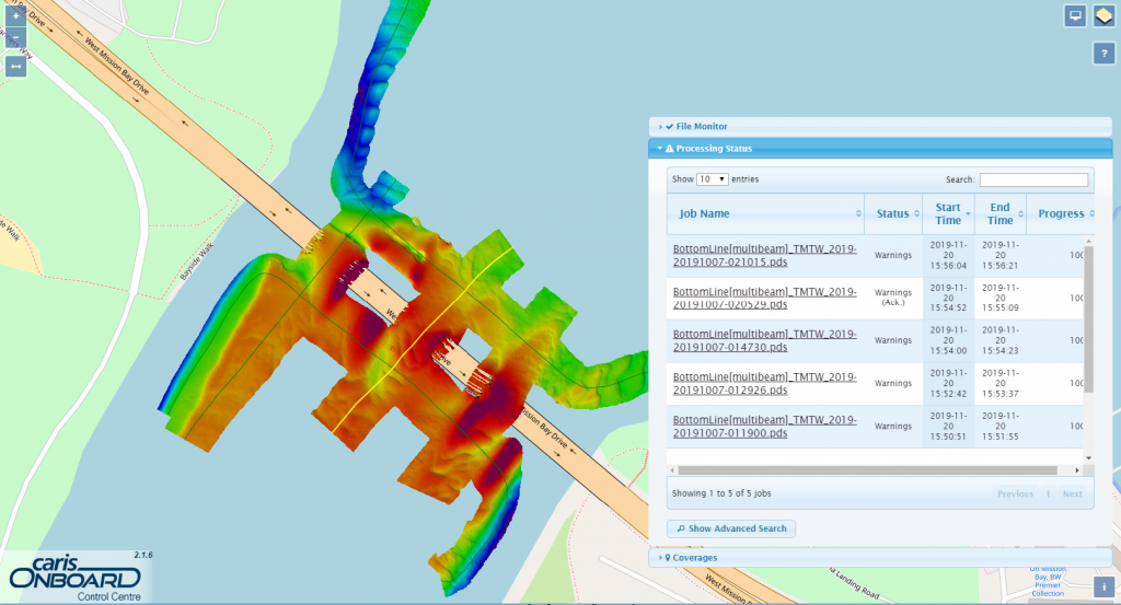
After defining the required processing workflow and data products for this survey, this workflow is uploaded to the CARIS Onboard Control Centre, a web-based application accessed from any standard web browser. Further, provided there is an internet connection to the platform, Control Centre can be accessed from any internet-connected desktop or mobile device.
With the workflow uploaded, the logging directory of the acquisition software is configured, and monitoring can begin. Once the survey begins, new files created in this location are detected as new data are processed, and a map viewer is provided to track progress on processing status, as well as review coverage and quality check using any generated products.
This real-time capability allows the operator to review the coverage and quality of a data set, as a semi-final product, at a glance during survey operations. As an additional efficiency, the remote connection capability would allow any supervisor (or client) to monitor progress in real time as well.
Once the survey is complete, in addition to the raw logged data products, the user now also has a fully processed CARIS project, ready for final processing and data QC in HIPS and SIPS.
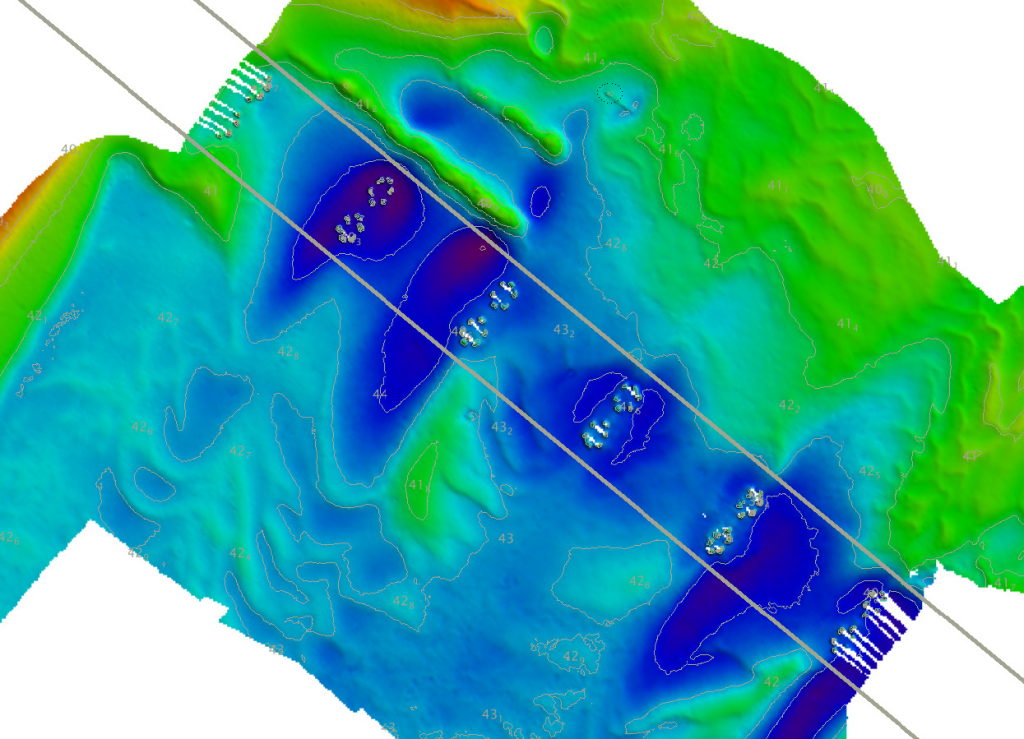
HIPS and SIPS is CARIS’s flagship desktop hydrographic data processing product. Backed by over 25 years of hydrographic processing experience, it offers essential capabilities and professional-grade tools that allow users to simultaneously process multibeam, side scan, single beam and scanning laser data sets. As a Teledyne product, HIPS and SIPS offers optimized and streamlined support for all Teledyne hardware products, including the Seabat T-series multibeam and Optech M3 laser. This allows seamless processing of both sensor products in a single workspace, as well as the generation of combined product deliverables. In this case, the software also allows application of post-processed SBETs and/or corrected tides after the survey is complete, which minimizes the amount of data reconversion and prevents the loss of any previous data edits.
The software is also capable of generating a significant variety of data products using industry-standard exchange formats, from full-density point cloud products to gridded products to decimated contours and spot features.
As the post-processing software of choice for most hydrographic offices around the world, HIPS and SIPS provides access to a full suite of products for any safety-of-navigation survey, including the industry-standard uncertainty modeling and CUBE processing workflow. Users can also generate standard charting products, such as contours, sounding sets and obstructions, directly from the source data using IHO standard definitions.
For engineering-focused projects, the Engineering Analysis Module add-in provides a suite of additional capabilities, including dredge/channel maintenance tools, volume computations and more.
Conclusion
Teledyne’s combined Lidar and sonar hardware solution improves productivity and efficiency in marine construction applications, including dredging, crane operations, piling and hydrographic survey. Teledyne software provides accurate 3D visualization to assist operators with underwater construction and inspection tasks, saving time and money, and ensures a safe work environment.
Teledyne software solutions allow collected data to be quickly processed into informative products to direct construction activities and provides a scalable database to manage the increasing volumes of high-resolution data being collected. Automated processing systems allow products to be derived during the survey with minimal user interaction, reducing training needs and providing the information that matters when it matters.
By leveraging a suite of integrated Teledyne products and services, surveyors can maximize their efficiency both during and after data collection to produce extremely high-quality data sets for their end-users. Teledyne offers a variety of sensor types and software packages to suit any operating requirement and data product deliverables.
 Charting the Deep: Understanding Our Oceans, Envisioning Our Future
  How LIDAR is helping to clean up our oceans