

How Precision Forestry Uses Lidar to Manage and Preserve Forests
Precision forestry has brought digital tools like lidar and aerial drones to transform an industry that hadn’t changed in 300 years.
Around the year 1700, the state of Saxony was in trouble. The large mining industry in the state was in financial straits. There was still plenty of ore in the ground, the problem was lack of trees. The mining industry had consumed all the old growth forests, meaning that ore could not be smelted nor mining structures built.
Enter Hans Carl von Carlowitz, a tax accountant and mining administrator. He saw the problem and knew something needed to be done about it. In 1713 he published Sylvicultura Oeconomica, the first book dedicated to sustainable forestry. Carlowitz became the founder of modern forestry and his methods, to varying degrees, persisted for 300 years. Forestry, as a field and an industry, has been remarkably slow to adapt to modern times.
That has started to change within the last decade.
Modern tools have begun to transform forestry. Granular analysis of soil has led to the creation of specific fertilizers suited to climate and species of tree being grown. Seedlings are selectively bred and cloned and raised in nurseries under controlled conditions. Harvesting is no longer a bunch of burly men in the woods with axes and chainsaws, but a mechanized process that takes into account supply chain planning. Satellites, airplanes and drones equipped with lidar and other multispectral sensors can monitor forests from the sky, giving unprecedented levels of data and helping to automate what had long been a manual process.
Combined, these methods are known by the term precision forestry. And, like most industries today, modern silviculture (forest management) begins with acquiring precise data.
Lidar From Above
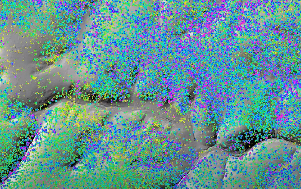
Drones, satellites and airplanes equipped with lidar have changed the forestry industry. Forest managers can not only track the growth, inventory and health of trees in a wide region, but also map the land on which those trees stand. For instance, water management is immensely important in tree growth. Precision topographical mapping from above can show the flow of water within an area. When combined with data on the height of the tree canopy, forest managers can draw granular insights and determine best growth patterns.
One example of aerial forestry mapping with lidar was performed from a Cessna 414a airplane over Arizona by engineering firm Merrick & Company using a pair of Teledyne Optech Galaxy G2 sensors. The plane flew over the region at an altitude of about 2,259 meters with a groundspeed of 170 knots. The data delivered back to the plane allowed researchers to map the ground along with areas of low, medium and high vegetation. Based on this data, the team could create a detailed Digital Elevation Model of the area, as well as mapping the tree crown points (the highest point of a tree) and create tree canopy polygons to map the density of leaf cover.
A proposed project from Open University in Milton Keynes, United Kingdom wants to go beyond aerial drones or airplanes. Called TreeView, the project aims to launch a SmallSat satellite to perform analysis of trees in the U.K. from orbit.
“A major pillar of UK’s national response to the climate change emergency is a significant increase in tree planting for carbon sequestration and storage,” said Dr. Kadmiel Maseyk, senior lecturer of environmental sciences at Open University, when the project received initial funding from the U.K. Space Agency. “TreeView will adopt a ‘NewSpace’ approach, which takes a more holistic and integrated approach satellite development, to develop a platform that will transform our ability to image down to the individual tree.”
TreeView aims to measure both the country’s forests, but also the trees in urban landscapes. The project aims to measure changes over time to, “to quantify carbon sequestration; assess vulnerability and detect the onset of climatic stress or disease outbreak to facilitate early intervention; and to measure the success and monitor compliance of tree planting programmes.”
Partners in the TreeView project include XCAM, In-Space Missions, RAL Space, Teledyne e2v, Forest Research, the Centre for Ecology and Hydrology, Grey Consultants and 2Excel-geo.
Remote sensing from the air or space can provide a variety of functions for precision foresting, including:
- Digital inventory: measurement of forest inventory, such as volume of trees and different kinds of species.
- Fire monitoring: can provide early detection of forest fires and help coordinate fire-fighting efforts.
- Pest and disease monitoring: to monitor the health of trees and provide early detection to mitigate outbreaks.
- Site-specific management: through digital models of the forests and surrounding area, sites can be managed more efficiently with high-precision data models.
- Data for forestry planning models: with data from inventory and management, planning models can be created to support forest management decisions.

More to Forests Than the Trees
Precision forestry is a relatively new practice that has brought digital transformation to a very old industry. And while precision forestry helps timber companies and governmental departments map and understand forests, its importance goes beyond ensuring sustainable forestry.
Forests are vitally important to mitigating climate change on Earth. Trees capture carbon, which keeps it from making its way to the atmosphere and adding to the greenhouse gases warming our planet. Precision forestry can help monitor carbon sequestration (how much carbon is trapped by trees), assist in carbon accounting, help in watershed development, aid soil and biodiversity conservation, and help preserve natural growth forests.
 Discovering Cities: Lidar Past, Present & Future
  Lidar makes its points at Europe’s dams