

ESG: Enabling A Better Future with Technology
Environmental, social, and governance is about considering the bigger picture for a better future. Teledyne technologies are helping companies and governments see what’s next.
Often ideas are not even doubted until the very moment they are proven categorically false. The “black swan theory,” popularized by essayist and statistician Nassim Nicholas Taleb, is based on an ancient European saying that presumed black swans did not exist – a saying which was reinterpreted when Dutch explorers found them in Australia more than a thousand years after the phrase was first popularized.
The theory attempts to explain the disproportionate role of high-profile, hard-to-predict, and rare events that are beyond the realm of normal expectations in history, science, finance, and technology. Such events, considered extreme outliers, collectively play much larger roles than regular occurrences.
Does it seem that ‘once-in-a-century’ events are happening quite frequently lately? Think of a not-so-hypothetical: a market bubble, or an invasion, a once-in-a-century weather event, or a global pandemic.
The practical aim is not to attempt to predict events—they are (by definition) unpredictable. Instead, the solution is to build resilience to negative events while still exploiting positive events. In the world of business and finance, one way to do that is by taking a larger view and considering more information when evaluating markets, risks, and opportunities.
Considering New Factors for Better Performance
What should be considered in the larger view? One of the most popular approaches is what is known as environmental, social, and corporate governance (ESG) investing, which relies on independent ratings that help assess a company’s behavior and policies when it comes to environmental and social impact as well as how the company is run. That can expand to analysis of how a company serves not just shareholders but stakeholders: workers, communities, customers, and the environment.
Global markets are taking a deeper look at this information as way to better predict long-term value creation in a business. There’s evidence that ESG information can better predict which companies can adapt and even thrive under hard-to-predict events: industry, regulatory and market shifts, new technologies, climate change, social and legal changes, and even pandemics. For example, S&P Market Intelligence found that ESG funds outperformed their index in the first year of the COVID-19 pandemic.
ESG investing appears to provide downside protection, especially during a social or economic crisis. Corporate sustainability initiatives appear to drive better financial performance due to mediating factors such as improved risk management and more innovation, especially over the longer term. Robust ESG strategy and reporting enable companies to strengthen their narrative on the journey toward long-term value and sustainability.
ESG-Enabling Technologies
How do scientists and engineers study climate change and predict weather? How can organizations develop new products and services that will succeed in future conditions? How can governments plan infrastructure, develop policies, and monitor compliance? In many cases, they are Teledyne’s products that make sustainable environmental efforts, research, policy and information services possible.
Across dozens of companies, Teledyne has become a key player in environmental instrumentation and imaging solutions for earth science and carbon monitoring, ambient air quality monitoring, instrumentation for ocean science and climatology, measurement of key environmental parameters, and the manufacturing of key green technologies like rechargeable batteries, hydroelectric dams, windmills, and solar panels.
Carbon monitoring and environmental and climate science
NASA has confirmed that extreme weather events are increasing. High-quality measurements are required to best understand how our climate is changing, and how to take action. Global measurement from space is proven to be one of the most cost-effective and comprehensive tools for studying climate change and the effects of human activities. Specialized image sensors are the “eyes” of orbital satellites that can monitor the earth’s atmosphere, continents, and ocean surfaces from space.
Teledyne’s high-performance imaging sensors are playing a big part in this effort.
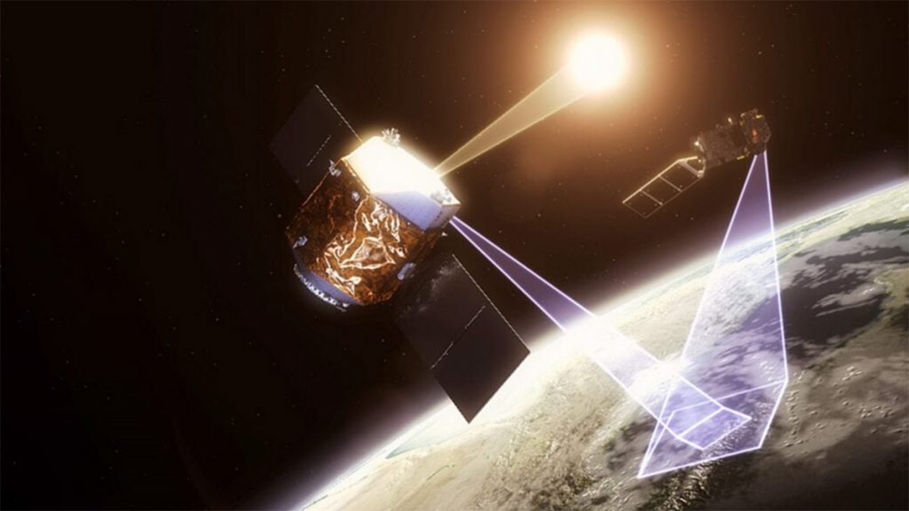
For example, the TRUTHS (Traceable Radiometry Underpinning Terrestrial- and Helio-Studies) mission will, for the first time, enable high-accuracy traceability of climate data and allow for the creation of a robust, space-based, top-of-atmosphere climate observation system. Its primary goals are to provide measurements for incoming and outgoing solar radiation between the earth and the sun, and to act as the primary calibration and bench-marking tool for orbital imaging and observation. Launching in 2026, TRUTHS will use short-wave infrared sensors from Teledyne e2v to drive its Hyperspectral Imaging Spectrometer (HIS) to monitor the solar radiance spectrum.
Greenhouse gases are just one aspect of atmospheric measurement. Also important is the radiation budget of the Earth — that is, how much radiation is received from the Sun and how much is re-emitted to space. Imbalance in the radiation budget can cause global warming.
A new NASA Earth science mission planned for launch in 2024 may achieve a transformational advance in our understanding of the global carbon cycle by mapping concentrations of key carbon gases from a new vantage point: geostationary orbit. The Geostationary Carbon Observatory (GeoCarb) will use a grating spectrometer to collect 10 million daily observations of the concentrations of carbon dioxide, methane, carbon monoxide and solar-induced fluorescence (SIF) at a spatial resolution of about 3 to 6 miles (5-10 kilometers).
Read more: The TRUTHS Satellite Will Help Provide the Most Accurate Climate Data in History
Read more: Tracking Climate Change with Satellite-Based Cold Atom Gravity Sensors
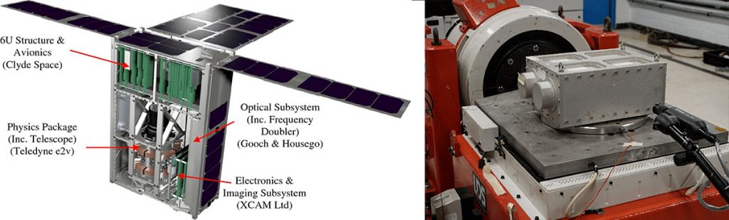
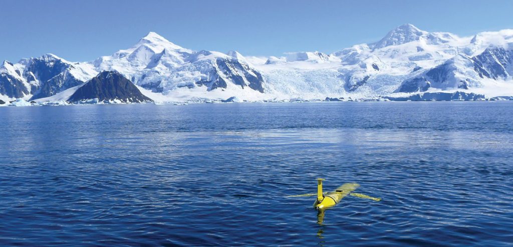
Another project, the Cold Atom Space PAyload (CASPA), is being led by Teledyne ev2 with partners including the University of Birmingham as science lead, XCAM, Clyde Space, Covesion, Gooch & Housego, and the University of Southampton. In space, cold atom gravity sensors could be used to carry out Earth observation to detect and understand mass transport processes which could lead to significant breakthroughs in our knowledge of and ability to monitor key components of the Earth system such as sea level, ice sheet melting and aquifer depletion.
The effect of changes in the Earth’s climate is reflected (literally) in the light from plants. NASA’s ECOSTRESS instrument on the International Space Station and NASA’s Surface Biology and Geology (SBG) mission depends on Teledyne’s visible-infrared sensors. ESA’s Copernicus Hyperspectral Imaging Mission for the Environment (CHIME), which is similar to NASA’s SBG mission, also will use Teledyne’s advanced visible-infrared sensor
While all these missions are filling gaps in our understanding of climate science, next generation instruments are required. Teledyne is at the forefront in development of sensors for the next generation LandSat, next generation GOES, and new constellations of weather satellites.
Tackling global plastic challenges
Although plastic has only been around for 60 years, it has become inseparable from how we live our lives. One of the largest issues with plastic waste is that the majority of it is intended for single-use, causing many people to throw. 91% of plastics are not recycled, ending up in landfills, or worse, our oceans.
Today marine plastic debris is one of the most significant threats to oceans, preventing sunlight penetration that harms plant and algae life-cycles. Enormous aggregate points for trash and pollution form around natural circulation points in the ocean currents called “gyres”. Understanding marine plastics is a challenge due to the remoteness of these sites.
Teledyne and The German Aerospace Center (DLR) are working together to bring imaging to help study marine plastic accumulation and clean up the world’s oceans. It is now possible to collect imagery that reveals the composition and density of these debris fields. With the use of the DLR Earth Sensing Imaging Spectrometer (DESIS) sensor aboard the Teledyne Multi-User System for Earth Sensing (MUSES) pointing platform on the International Space Station (ISS), coupled with the ocean current model General NOAA Operational Modeling Environment (GNOME), investigators will be able to both predict the location of and characterize these collection points. This will allow scientists to study the extent, monitor changes, and plan mitigation actions for the accumulated debris in these areas.
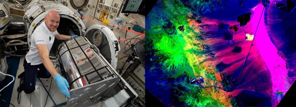
DESIS is supporting resource and environmental monitoring and has collected over 125,000,000+ square kilometers of hyperspectral imagery of Earth. TBE has distributed DESIS data to 450+ customers and organizations to support business and research.
Read more: DESIS and Ocean Garbage Research
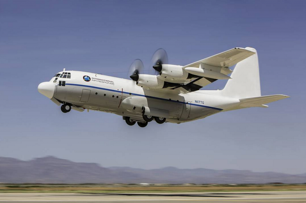
Space-based sensors are complimented by a variety of airborne instruments that focus on high resolution measurement of targeted areas. The Ocean Cleanup’s aerial expedition used a combined LIDAR-Hyperspectral-RGB imaging solution from Teledyne Optech to gain a greater understanding of the depth and width of the debris polluting our oceans. It’s considered the most efficient airborne bathymetric mapping system on the market, and uses lidar to sense what more conventional imaging systems can’t.
The Teledyne Optech CZMIL Super Nova is a coastal and marine mapping system that can find objects 80 metres below the ocean’s surface and produce high-resolution 3D data with its laser function, hyperspectral imaging and digital metric camera. This three-pronged approach collects information at a rate of 70,000 measurements per second, generating results with a very high degree of accuracy.
The sensor results, combined with other data will feed into the engineering behind the group’s upcoming cleanup projects, where a v-shaped 100 kilometer-long floating barrier will act as an artificial shoreline. The barrier will move with the ocean’s natural currents, collecting and concentrating the ocean trash for easier cleanup while while minimizing harm to ocean life.
Read more: How LIDAR is helping to clean up our oceans
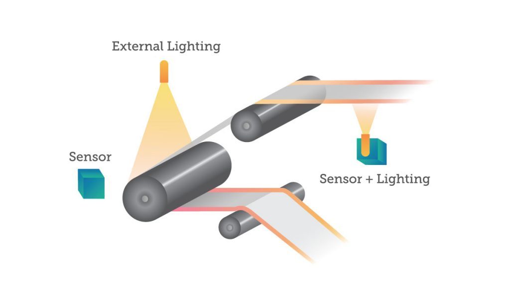
Teledyne DALSA also has a variety of vision solutions that are being used to help sort plastic, reducing costs of recycling and improving efficiency, and ultimately, keeping it out of our landfills and oceans. Line scan cameras are extremely useful in visible spectrum sorting where a machine vision solution that is able to distinguish between plastics and glass. Other solutions use hyperspectral imaging to sort recyclables, identifying the subtle differences between different types of hydrocarbons in paper, cardboard, and plastics.
With nearly 50 different types of plastics, everyone will need to work together toward reducing and eliminating the effects of plastic on the Earth. Plastic sorting enables efficient recycling, resulting in reduced costs and lowering greenhouse gases and toxins in our atmosphere. To learn more about sorting plastic using machine vision, see our other articles on the topic.
Read more: Sorting it Out: How imaging systems are improving the way we recycle
Tracking the pandemic and protecting populations
Throughout the COVID-19 pandemic, scientists and industries have turned to Teledyne vision solutions to fight back. Thermal imaging solutions helped authorities screen for fever symptoms in key locations like airports, factories and medical facilities. Imaging-based genome sequencing helped scientists track the virus and understand its mutations over time.
The NASA COVID-19 Dashboard features imaging data collected by a variety of earth-observing satellites and instruments aboard the International Space Station which carry Teledyne technology. The global maps are searchable by several categories of observable change, including economic indicators, such as lulls in shipping and construction activity, and environmental factors, such as water quality and climate variations, helping scientists study the pandemic’s effects on the Earth system.
Making green tech safer and more successful
Wind turbines are massive machines, often the equivalent of a 32-story building from the base to a blade at the apex of its rotation. Keeping turbines in good working order is essential for efficient energy production, but also the safety of anyone in a turbine’s immediate vicinity.
With the help of aerial drones equipped with thermal imaging equipment, these turbines can be examined in an hour instead of days. Cameras can detect the tell-tale heat signatures of material stresses long before a component breaks down entirely, causing the wind turbine to be out of commission for an extended period of time.
Read more: How Thermal Imaging Can Help Prevent Wind Turbine Failures
The transition to green energy in the coming decades will require a commensurate increase in battery production and innovation. Lithium-ion batteries will be the workhorse of a green energy revolution in the near to medium future, storing power for nearly everything, from electric vehicles and eventually airplanes, to homes and commercial buildings.
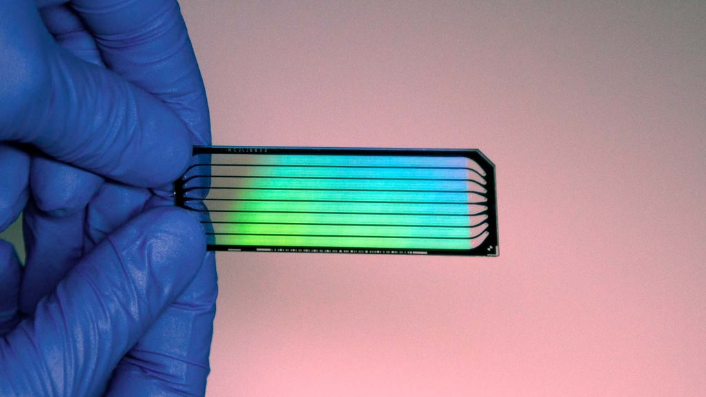
While lithium-ion battery production may be conceptually simple with coated electrode stacked sheets and an electrolyte solvent, the actual process is fairly complicated and sensitive. The thickness of the coatings on the electrodes can have a significant effect on a battery’s performance or even its stability. Line scan cameras—such as the Linea family of cameras from Teledyne DALSA—are backed by machine learning algorithms that help automate and streamline the quality assurance stage of lithium-ion battery manufacturing.
Read more: How Machine Vision is Enabling the Future of Lithium-Ion Batteries
Solar panel manufacturing is similarly important, and faces many of the same challenges. Automation and inspection are both critical to high-quality, consistent, and high-throughput solar panel products. There are delicate components and multiple layers, all requiring precise placement and alignment. Material handling, cell cutting, and component bonding are all very automated in modern factories, but an error in any one of them risks lower initial performance, and shorter operational life for each solar panel.
This makes inspection crucial. End-of-line testing of electrical parameters like current voltage and peak power rating ensure that panels perform at expected standards. Imaging allows us to look for quality issues, such as cracks and misalignments that indicate initial quality, but also longevity of the panel itself in the field.
Read more: Bright Light, Big Future: Solar Power on the Rise
So much more than imaging
Teledyne’s imaging solutions reach deeply into the efforts we’re making to both understand and tackle our most daunting global challenges. And it doesn’t stop at imaging. Teledyne companies also produce a wide range of air and water monitoring instruments, including autonomous systems that profile the world’s oceans. Teledyne’s product portfolio also includes sophisticated air and water quality monitoring instruments to help keep the air we breathe and the water we drink clean. The companies design, produce and distribute sophisticated air quality instruments that measure hazardous gases and particulate matter in real-time. They also have products designed to improve the efficiency of motors, motor drives and industrial automation systems to reduce energy consumption.
To learn more about the future vision and global scope of Teledyne’s ESG-related efforts and solutions, download the 2022 Teledyne Technologies Corporate Social Responsibility Report, where they have compiled a global inventory of their emissions as well as their ESG and sustainability efforts and goals.
 Bright Light, Big Future: Solar Power on the Rise
  How Machine Vision is Enabling the Future of Lithium-Ion Batteries